From an ultralight's perspective
4 Mar 2013
-
ITER Communication
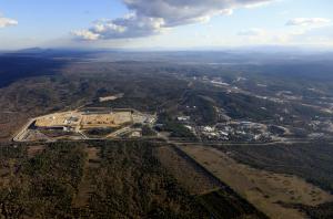

Lost in the wild: the 42-hectare ITER platform from an altitude of 500 metres. To the right: CEA-Cadarache; to the left, Mount Petit and Mount Gros Bessillon (~ alt. 800 m). © MatthieuCOLIN.com / ITER Organization
The last time an aerial photo survey was conducted of the ITER site, in September 2011*, the lower basemat had yet to be poured in the tokamak seismic pit; cladding and roofing operations were underway on the Poloidal Field Coils Winding Facility; and windows were being installed at ITER Headquarters.
A year and a half later, a four-hectare electrical switchyard is in place and 500 people work from the completed Headquarters building. Preparatory works have just begun for the Tokamak Complex basemat (the B2 slab) that will rest atop the seismic pit's 493 concrete columns (plinths) and pads.
Whereas in 2011, vast expanses of barren land still existed between the different work areas on the platform, this new series of photographs, taken two weeks ago, shows a much different landscape: mounds of earth, trenches, and material and vehicle storage areas now occupy most of the available space between the buildings.
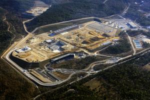

In the Seismic Pit, the radial pattern of the plinths is clearly visible from the air. At a short distance from the platform, surrounded by trees, the rubble storage area. © MatthieuCOLIN.com / ITER Organization
In the seismic pit, the radial pattern of the plinths is clearly visible from the air. Nearby, the completed sections of the Assembly Hall foundation slab reflect the mid-afternoon winter sun. From the Headquarters building, long shadows extend almost all the way to the deserted parking lot (the photograph was taken on a Saturday). On the "green" rooftops of the Access Control Building, the Amphitheatre and the Medical Building, the sedum plants wear their winter colour—they will turn from red to green in the summer and from green to yellow in the fall.
Photographer Matthieu Colin carried out the latest ITER aerial campaign from an ultralight aircraft flying at an altitude of 500-900 metres. (The September 2011 photographs had been taken from a helium-filled balloon hovering at 70-100 metres above ground.)
* The December 2012 pictures that appear in our website's aerial photo gallery were taken from a 40-metre-tall cellular radio tower.
Click here to view more aerial photographs of the ITER site.